Tuesday, February 7, 2012

2012 MWN storm chase season dedicated to Andy Gabrielson.

Courtesy of SevereStudios.com
        As most of the severe weather community knows, we lost a dear friend and unbelievably talented colleague last Saturday in a horrific car wreck.  Andy Gabrielson was so dedicated to storm chasing that he was awarded an Emmy in 2011.  He dedicated almost every moment of his life to storm chasing, racing, and his family.  Andy was 25 years old, from Luverne, MN, and leaves behind a wife and young daughter.  He will be missed dearly by all, and forgotten by none.  With that, I am honored to announce that our entire 2012 MaximumWeather.Net storm chase season will be dedicated to Andy.  Our chase vehicle will proudly display an "AG" all season and videos will include an "In memory of Andy" credit at the end.  If anyone is interested in learning more about Andy and what he did you can visit FindtheTornado.com (Andy's site) or SevereStudios.com where you can find information on services and donate to the Gabrielson family fund.  You will find full links below. 

       On a seperate note, I did not know Andy personally, however we followed each other on twitter and Andy occasionally replied to some of my tweets.  He seemed like the kind of person that would never judge and always give you a chance.  He is one of the reasons I do what I do.  Please Please Please join me in donating to his family's fund and celebrating the upcoming storm season for him.  In closing I will say this, Andy, this ones for you... #cheeseburger

To donate visit: http://severestudios.com/donate-andy-gabrielson-fund

Sunday, November 20, 2011

***Late-Season Severe Outbreak Taking Shape***

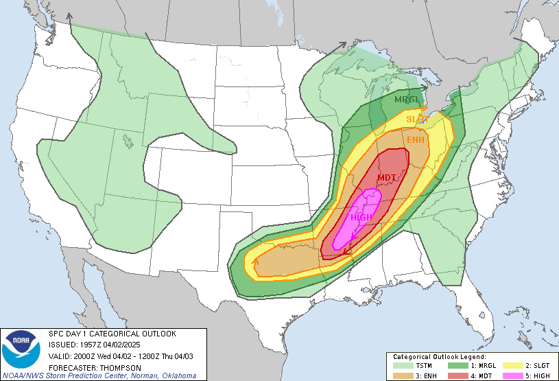
A late season multi-day severe weather event is taking shape for parts of the South and Southeast for Monday-Wednesday.  Moisture from the Gulf, along with ample wind shear, will return to TX, AR, and OK.  These will provide the necessary fuel for significant severe weather with tornadoes, damaging winds, and destructive hail all becoming likely.  The primary threat areas for Monday will be over much of Central/Northeastern TX, up through Southern OK and Western AR. Tuesday will bring a more broad threat with severe storms possible through much of the mid/lower MS valley.  The cold front will continue East bringing the threat all the way to the Carolinas.  Many Watches and Warnings are anticipated so be sure to check back and stay tuned to local forecasts for updates.  Follow me on Twitter for up to the minute updates at @MaximumWeather.  These storms will have the potential to cause significant damage to life and/or property, be sure to have an emergency plan in place in case the weather turns quickly. -BW

Friday, October 28, 2011

***Early Season Snowstorm Taking Shape in the Northeast***

A rare late October snowstorm is taking shape over parts of the Northeast.  A swath of snow will fall through many states with an estimated 25 million people potentially affected.  Snowfall totals will very greatly with 8-12" amounts inland being common with some locally higher amounts.  The snow will be wet and heavy with the potential to create dangerous travel conditions and widespread power outages.  Expect major airport delays for anyone planning to travel by air.  If you are affected by watches and warnings be sure to have an emergency plan in place, stay tuned to local media, and listen NOAA weather radio for the latest updates for your area.  Check back for updates....

Tuesday, October 25, 2011

Hurricane Rina ***Updated 10.25.11***


Images: NOAA/NWS/NHC
Hurricane Rina is now a very strong Category 2 hurricane with maximum sustained winds of 110mph and a central pressure of 970mb and falling.  Hurricane warnings are in effect for the eastern Yucatan coastline including popular vacation spots such as Cozumel, Playa Del Carmen, and Cancun.  Rina is forecast to further strengthen over the next 48hrs into a major Category 3 storm.  Any preparations to preserve life and property must be rushed to completion as conditions will quickly deteriorate in warned areas.  A storm surge of 5-7ft is anticipated along immediate coastal areas.  Rina will also bring 8-16 inches of rain which will most certainly cause flash flooding.  Conditions will begin to decline Wednesday afternoon/evening through Thursday.  This is a dangerous storm, if you are in the projected path have an emergency plan.  Updates will come as conditions warrant. See http://www.nhc.noaa.gov/ for more detailed information.

Monday, October 24, 2011

Hurricane Rina ***UPDATED 10/24/11 8:30pm CDT***

Image: NOAA/NWS/NHC
Hurricane Rina is currently gaining strength in the Southwest Caribbean tonight.  Rina quickly gained strength early this morning and gained hurricane strength winds mid-morning.  Current strength is Category 1 with winds max sustained at 75mph.  Movement in WNW at 3mph and the last pressure reading was 989mb and falling.  Rina is expected to continue to gain strength over the next 48hrs. at which time it could be a "major" Category 3 hurricane.  Locations currently in the track include Cozumel, Playa Del Carmen, and Cancun.  Some model uncertainty does exist so check back for updates. -BW 

Wednesday, May 25, 2011

Explosive Tornado Outbreak ***Day 3*** Updated 5.25.11


Images: NOAA/NWS/SPC
Another "High Risk" day is turning the skies black across much of the nations mid-section.  There are currently no less than six tornado watches issued as of 6pm CDT.  Three of these watches have the rare tag of PDS (Particularly Dangerous Situation).  2011 is proving to be the worst year in recorded history for tornadoes.  Tornado related deaths for the year topped 500 with total number of tornadoes right around 1200 which is twice the national average for this time of year.  The number of tornadoes is not what worries meteorologists, but rather the intensity.  Under "normal" circumstances the country could go several seasons without an EF-5 tornado, however this season boasts four EF-5's.  Previously, the most recent EF-5 was in 2008.  There is the possibility of more tonight.  Stay tuned for updates and Stay aware of any watches and warnings that may be issued.

Tuesday, May 24, 2011

Tornado Nation ***Updated Tue. 5-24-2011***

Tornadoes have struck up and down the country's mid section over the past three days leaving utter devastation and death in their wake.  Sadly, 2 people were killed in an EF-1 tornado that cut a path through the highly populated North-side of Minneapolis, MN on Sunday afternoon.  The same evening a historically tragic event unfolded in the town of Joplin, MO (pop. 50,000) where an EF-5 tornado ripped through the town destroying absolutely everything in its path leaving at least 122 dead and making it the single deadliest tornado since 1950.  Once again, tornadoes carved a deadly path through Oklahoma tonight (Tue.) leaving at least 7 dead with storms expected to continue overnight and unfortunately hit some of the same areas as Sunday's storms.  The atmosphere will re-load for tomorrow across portions of the mid and lower Mississippi valleys.  The SPC in Norman, OK has a day 2 Moderate Risk for a large area with another major severe weather outbreak likely.  More strong/violent long-track tornadoes will be possible in many areas including Missouri, Arkansas, Illinois, Indiana, Tennessee, and Mississippi.  Stay tuned to your local forecast and check W.W.W. for continued updates on this potentially record breaking year. 

Sunday, May 22, 2011

Tornado Watch 322 has been issued for much of Southeast MN including the Twin Cities.

Tornado watch 322 has been issued for parts of MN, WI, and IA. The watch is effective until 8 pm CDT. Stay tuned for further updates from worldswildestweather.com
Published with Blogger-droid v1.6.7

Thursday, April 28, 2011

Tragedy strikes in the South.

As many of you already know a violent and very deadly outbreak of tornadoes occurred over the last two days with the most severe damage occurring in Alabama, Georgia, Mississippi and Tennessee.  The latest death toll stands at just over 200 with that number sure to rise as search and rescue crews sift through rubble and debris.  Many meteorologists are calling this the outbreak of the century as the scope of the damage is fully assessed.  I have not heard an official review of the storms yet but after reviewing several different videos and pictures I would say without a doubt that at least one or more of these tornadoes will be rated EF-5.  In the weather world this is also known as "The finger of God" due to its ability to erase anything in its path.  Updates on storm specifics are coming in very slowly as almost 1 million people are without power so stay tuned for further information.  Many people ask why I do what I do and this is the reason.  I have to say that due to the work of dedicated meteorologists and storm chasers/spotters many lives were probably saved.  If you would like to see video and pictures of the storms visit weather.com or cnn.com for the latest updates.  be sure to follow on Twitter (@worldswildestweather) for breaking W.W.W. news.  Also, please take a moment to remember victims of this disaster as most of us were unaffected by this tragedy. Have a good day!

-Brian

Wednesday, April 27, 2011

Southeast U.S. under siege!

The southeast US is being hammered by tornadic supercell thunderstorms tonight as another round of dangerous weather strikes tornado alley. For the second day in a row the SPC issued a "High Risk" for severe weather meaning life threatening weather was immenent. Reports of damage including the collapse of a three story motel in Georgia are already coming in. We will continue coverage overnight into the morning hours with news as it comes in. Be sure to follow on twitter (@worldswildestwx) for breaking news updates. Have a pleasant evening and be sure to check your local forecast.
Published with Blogger-droid v1.6.7

Tuesday, April 26, 2011

Tornado Outbreak over TX, AR!

Image: NOAA/NWS/SPC
An outbreak of strong to violent tornadoes and hail the size of baseballs is occurring over parts of Texas and Arkansas this afternoon/evening.  This is the most dangerous severe weather outbreak of the year so far with the SPC (spc.noaa.gov) issuing a rare High Risk probability for severe weather over several states in the ARK.LA.TEX region.  This has also had the even more rare tag of a PDS watch which the SPC calls a particularly dangerous situation. Today is the type of day that all meteorologists, spotters, and chasers prepare for their entire carers.  This is the time when lives are in real danger and can be saved as long as warnings are heeded.  Stay tuned for further updates and details and follow on Twitter @worldswildestwx!

Catastrophic weather event taking shape over parts of the south.

A massive outbreak of severe weather is taking aim at parts of Texas, Arkansas, Oklahoma, and Louisiana. The Storm Prediction center has issued a high risk for severe weather, which is the top of the scale as far as threats go. Strong to violent long track tornadoes are expected as well as a widespread swath of wind damage. Stay tuned to this blog for further details.
Published with Blogger-droid v1.6.7

Saturday, April 9, 2011

****MODERATE RISK FOR SEVERE WEATHER TODAY****

Image: NOAA/NWS/SPC
A warm front will push north this afternoon igniting an outbreak of severe weather across Southern MN and parts of SD, IA, and WI.  The main threat will be very large and destructive hail and isolated tornadoes.  The storms will develop over Nebraska and and South Dakota and spread to the northeast through the late afternoon and evening.  The storms will be more of a supercell form rather than a line form which favor the hail and tornado threat rather than damaging winds.  Please continue to monitor local forecasts as this is a potntially dangerous situation.  Just wanted to mention that the weather here in Cozumel is beutiful and HOT!  Unfortunatly, I will miss out on the action today but that's ok... Im in Mexico!  Have a great day!

Thursday, April 7, 2011

7.1 Japan Aftershock ****Updated****

A very strong aftershock rocked the same region affected by the 9.0 earthquake nearly a month ago.  Initially measured at 7.4, it was later downgraded to a 7.1 by the USGS in Boulder, CO.  Even at 7.1 the shaking was felt as far away as Tokyo (approx. 200 miles).  The aftershock occurred at 11:32pm Japan Time or 9:32am CDT.  This is not what the Japanese need considering the effect that the 9.0 quake had.  There has been no reports of damage or injuries due to the fact that it may be hard to differentiate between events.  Tsunami warnings were briefly posted but quickly canceled once the threat had been better assessed.   Meanwhile, the weather here in MN was very pleasant with temps in the 60's around the Twin Cities and plenty of sunshine.  The weather situation could change dramatically this weekend with our first shot at severe weather coming on Saturday afternoon (If your going to Target Field for the Twins game keep an eye on the forecast).  It appears possible at this time that the threat for all modes of severe weather will be possible with the arrival of a strong low pressure system from the southwest and moisture from the Gulf of Mexico.  Speaking of Mexico, I will be updating from the island of Cozumel starting tomorrow (April 8) and returning April 15.  Please understand if updates are a bit slow as computer access is very limited.  If severe weather erupts this weekend be sure to stay safe and point that camera to the sky!  Have a great evening!
Published with Blogger-droid v1.6.7

Monday, April 4, 2011

Massive Line of Storms Moves East!


Image: NOAA/NWS
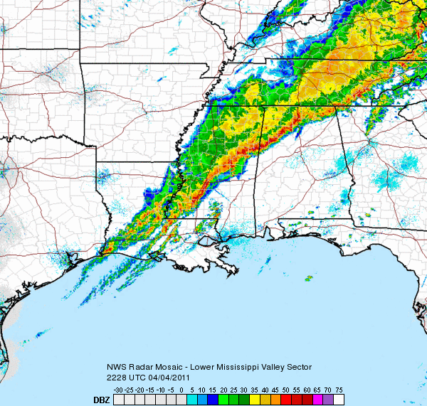
An intense line of storms is surging East this evening creating extensive damage in its wake.  The Storm Prediction Center issued a Moderate Risk for severe weather for the second day in a row meaning the severe weather season is in full swing.  A cold front surging east as it circles the low pressure system will produce storms with destructive hail, deadly lightning, and tornadoes over a large part of the South and East.  This is a very dangerous situation so please monitor local forecasts if you are in affected areas.  This line has a history of producing huge hail, tornadoes, and damaging wind gusts.  These threats will continue overnight and into Tuesday morning for much of the eastern seaboard.  Check back for updates!

Saturday, April 2, 2011

Severe weather threat for Mississippi Valley Sunday.

Severe weather will roll through the Mississippi Valley and the Middle Plains Sunday afternoon and evening.  Very warm and moist air will push north with the arrival of a strong low pressure center.  A cold front/dryline will dig to the south and east combining with enough wind shear to create rotation in the atmosphere for tornadic supercells.  Along with the tornado threat, a threat for very large and destructive hail will exist as well.  The storms are expected to become more linear with the threat for damaging winds becoming more likely overnight into Monday.  Check back for updates on this developing weather situation.  Have a great night!

Tuesday, March 29, 2011

Supercells blowing up in Lower Mississippi Valley!

Image: NOAA/NWS/SPC
Tornado Watch 72 is in effect until 10:00 CDT for much of Southern Louisiana and Mississippi.  Tornado Warnings are now in effect just to the west of New Orleans.  A severe thunderstorm watch is also in effect for much of central Texas.  Storms are possible with large hail and damaging winds being the primary threat. These storms are expected to converge into one very large storm complex and continue to the East with the threat for damaging winds and isolated tornadoes overnight.  Check your local forecast and have your NOAA weather radio tuned for additional updates.  Have a safe night!

-Brian

Monday, March 28, 2011

2011 Extreme Weather Team T-shirts Just Arrived!

The new WorldsWildestWeather.com 2011 Extreme Weather Team T-shirts have just arrived and look great!  They are in extremely short supply with only 11 being printed and 2 already spoken for.  If demand is high enough I may order another limited run however the shirts are not cheap to print so it won't be many.  I designed the shirts online at CustomInk.com and I have to admit they did a great job with the shirts.  The idea is that we will have a shirt for every year with this being the first for the Extreme Weather Team.  We are still deciding exactly how the shirts will be available so check back for updates.  I would like to hold some sort of photo/video contest for the upcoming storm season or possibly sell a few to recover some operating costs.  I will need to save a few for those of you who are crazy enough to chase storms with me so keep that in mind.  Any suggestions are welcome as well.  Check back soon!

Friday, March 25, 2011

Crow River flooding at Delano ***UPDATED***

Photo: Greg Wright


Image: NOAA/AHPS

With sandbags at the ready, the city of Delano is ready to take on the annual Crow River flood waters that slowly continue to rise.  At the Bridge St. bridge the water currently stands at 18.15ft with an expected crest of about 19.2ft sometime Saturday afternoon. A backhoe has been brought in to break up an ice jam as of 2:30pm Friday.  If the predicted crest verifies, the 2011 crest will fall about a foot shy of last years crest of 20.3 ft.  This is good news to all those living along the Crow River considering they do not need a repeat of 1965's record setting crest of 23.2ft.  Fortunately the temps have stayed cool enough to prevent a rapid runoff of the newly fallen snow, and should stay that way for the next week or so.  The other bit of good news is that there also little to no precipitation forecasted over that time which will help rivers slowly recede.   We will be monitoring the river closely over the next several days so stay tuned for updates!

Wednesday, March 23, 2011

Moderate Risk of Severe Weather Today for KY/WV/OH

Image: NOAA/NWS/SPC
A strong line of storms from the same system that brought us rain, sleet, and heavy snow yesterday is moving East and bringing with it the threat for severe weather across several states.  This system is responsible for an EF-2 rated tornado in Iowa which had an 11 mile damage path with no known injuries.  The tornado threat will decrease as daylight fades and the storms become more linear, however the threat for high winds and hail still exists.  If you are in any of the affected areas stay tuned to your local forecast for details.
         Meanwhile, here in MN we got a dose of old man winter again... I know, I'm sorry.  Here in the Twin Cities it rained for about a day, then proceeded to sleet for about 4-6 hours, then changing to snow which has just ended recently.  It is a very different story depending on which direction you go from here.  The bad news is that this is precipitation that the rivers did not need.  The forecast for the lakes and rivers will depend highly on the temperature and precipitation over the next week to ten days.  At this time it appears that temps will stay cool enough to allow for a gradual melt of new snow.  Check back soon for updates as the 2011 Extreme Weather Team T-shirts will arrive April 4 and they will go fast!

Lightning

Lightning
Photo: Matt Sauerbrey 8.11.07